Sorin Cosoveanu and Frédéric Zanetta called my attention to five newly formed prefectures. They are described under Change history. There
is some confusion over whether Anié is a prefecture or a sub-prefecture; I concluded the former.
| Prefecture | HASC | Population | Capital |
| Agou | TG.PL.AG | 84,890 | Agou-Gadzepé |
| Akébou | TG.PL.AK | 62,245 | Kougnohou |
| Amou | TG.PL.AM | 105,091 | Amlamé |
| Anié | TG.PL.AN | 95,090 | Anié |
| Assoli | TG.KA.AS | 51,491 | Bafilo |
| Avé | TG.MA.AV | 97,830 | Kévé |
| Bas-Mono | TG.MA.BM | 88,846 | Afagnangan |
| Bassar | TG.KA.BA | 119,717 | Bassar |
| Binah | TG.KA.BI | 70,054 | Pagouda |
| Blitta | TG.CE.BL | 137,658 | Blitta |
| Cinkassé | TG.SA.CI | 78,592 | Cinkassé |
| Dankpen | TG.KA.DP | 130,723 | Guérin-Kouka |
| Danyi | TG.PL.DY | 38,742 | Danyi-Apéyémé |
| Doufelgou | TG.KA.DO | 78,635 | Niamtougou |
| Est-Mono | TG.PL.ES | 121,789 | Elavagnon |
| Golfe | TG.MA.GF | 1,570,283 | Lomé |
| Haho | TG.PL.HA | 247,817 | Notsé |
| Kéran | TG.KA.KE | 94,061 | Kandé |
| Kloto | TG.PL.KT | 139,043 | Kpalimé |
| Kozah | TG.KA.KO | 225,259 | Kara |
| Kpélé | TG.PL.KP | 75,890 | Kpélé-Adéta |
| Kpendjal | TG.SA.KP | 155,091 | Mandouri |
| Lacs | TG.MA.LC | 172,148 | Aného |
| Moyen-Mono | TG.PL.MO | 77,286 | Tohoun |
| Ogou | TG.PL.OU | 226,308 | Atakpamé |
| Oti | TG.SA.OT | 190,543 | Mango |
| Sotouboua | TG.CE.SO | 158,425 | Sotouboua |
| Tandjouaré | TG.SA.TA | 117,519 | Tandjouaré |
| Tchamba | TG.CE.TB | 131,674 | Tchamba |
| Tchaoudjo | TG.CE.TD | 190,114 | Sokodé |
| Tône | TG.SA.TN | 286,479 | Dapaong |
| Vo | TG.MA.VO | 210,075 | Vogan |
| Wawa | TG.PL.WW | 100,974 | Badou |
| Yoto | TG.MA.YO | 165,596 | Tabligbo |
| Zio | TG.MA.ZI | 295,177 | Tsévié |
| 35 divisions | 6,653,945 | |
|
Change history:
- 1960-04-27: Togo became independent. Before that time, the secondary subdivisions were ten cercles (circles). The
circles were replaced by 17 circonscriptions administratives (administrative circumscriptions), further subdivided into
158 cantons. The circumscriptions were Akposso (Hihéatro), Aného, Atakpamé, Bafilo, Bassari, Dapango, Kandé, Klouto
(Palimé), Lama-Kara, Lomé, Niamtougou, Nuatja, Pagouda, Sansanné-Mango, Sokodé, Tabligbo, Tsévié. The capitals had the
same names as the circumscriptions except as indicated in parentheses.
- 1968-01-26: Sotouboua circumscription created from parts of Atakpamé and Sokodé.
- 1969-02-22: Vogan circumscription split from Aného.
- ~1970: Name of Sansanné-Mango circumscription, but not its capital, changed to Mango. This is the set of
circumscriptions at that time. (Source: Encyclopædia Britannica, 1984 edition.)
| Circumscription | Reg | Population | Area(km.²) |
|---|
| Akposso | PL | 132,000 | 4,382 |
| Aného | MA | 121,000 | 712 |
| Atakpamé | PL | 106,000 | 6,145 |
| Bafilo | CE | 29,000 | 938 |
| Bassari | CE | 95,000 | 6,330 |
| Dapango | SA | 181,000 | 4,840 |
| Kandé | KA | 42,000 | 1,692 |
| Klouto | PL | 77,000 | 2,790 |
| Lama-Kara | KA | 96,000 | 1,085 |
| Lomé | MA | 231,000 | 345 |
| Mango | SA | 58,000 | 3,762 |
| Niamtougou | KA | 52,000 | 1,120 |
| Nuatja | PL | 157,000 | 3,658 |
| Pagouda | KA | 45,000 | 465 |
| Sokodé | CE | 106,000 | 5,692 |
| Sotouboua | CE | 68,000 | 7,490 |
| Tabligbo | MA | 72,000 | 1,250 |
| Tsévié | MA | 156,000 | 3,338 |
| Vogan | MA | 132,000 | 750 |
| 19 circumscriptions | 1,956,000 | 56,784 |
- Reg: Region in which the prefecture lies.
For key, see Regions of Togo page.
- Population: 1970-04-30 census.
|
- Note: Bafilo and Bassari circumscriptions are pretty clearly in Kara region according to current maps.
Either the EB was mistaken, or the boundary between Kara and Centre region changed.
- 1974-05-08: Akposso circumscription split into Amlamé and Badou.
- 1975-02-03: Tchamba circumscription split from Sokodé.
- ~1982: Name of Dapango circumscription changed to Dapaong.
- 1981-06-23: Laws No. 81-8 and 81-9 took effect. Status of circumscriptions changed to prefectures. These laws may
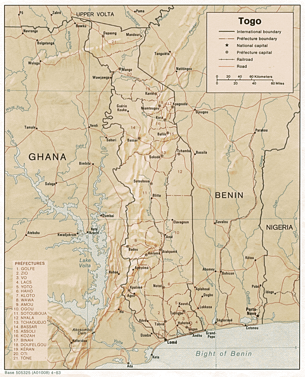
also have been responsible for creating Kara region. Here are a
map
 and another
map showing the prefectures as of the period roughly from 1981 to 1995.
and another
map showing the prefectures as of the period roughly from 1981 to 1995.
| Prefecture | ISO | FIPS | Reg | Alternate |
|---|
| Amlamé | AM | TO01 | PL | Amou |
| Aného | AN | TO02 | MA | Anécho, Lacs |
| Atakpamé | AT | TO03 | PL | Ogou |
| Badou | BD | TO15 | PL | Wawa |
| Bafilo | BF | TO04 | CE | Assoli |
| Bassar | BS | TO05 | CE | Bassari |
| Dapaong | DA | TO06 | SA | Dapango, Tôné |
| Kanté | KA | TO07 | KA | Kandé, Kéran |
| Klouto | KL | TO08 | PL | Kloto, Kpalimé, Palimé |
| Kpagouda | KP | TO14 | KA | Binah, Pagouda |
| Lama-Kara | LK | TO09 | KA | Kara, Kozah |
| Lomé | LO | TO10 | MA | Golfe |
| Mango | MA | TO11 | SA | Oti, Sansanne-Mango |
| Niamtougou | NI | TO12 | KA | Doufelgou |
| Notsé | NI | TO13 | PL | Haho, Nuatja |
| Sotouboua | SO | TO16 | CE | |
| Tabligbo | TA | TO17 | MA | Yoto |
| Tchamba | TB | TO19 | CE | Nyala |
| Tchaoudjo | TO | TO20 | CE | Sokodé |
| Tsévié | TS | TO18 | MA | Zio |
| Vogan | VO | TO21 | MA | Vo |
- ISO: Codes from ISO/DIS 3166-2. (Duplicated code
NI is
an error in the draft standard.)
- FIPS: Codes from FIPS PUB 10-4.
- Reg: Region in which the prefecture lies. For key, see
Regions of Togo page.
- Capital: Capitals have the same names as their
prefectures, as shown in the first column.
- Alternate: Alternate and variant names for the prefecture.
- Note: Klouto and Palimé are both cities in Klouto prefecture.
The alternate names may be due to a change of capital.
|
- The CIA World Factbook (1990-98 editions) said that Togo was divided into circumscriptions, noting that their status
may have been changed to prefectures. It gave a list which was approximately the same as the one above. It said that
name changes had been reported for the prefectures, replacing the prefecture name with one of its alternate names. In
1992 and later editions, some errors crept in. Pagouda appeared twice in the list, and Nyala and Tchamba were listed as
two separate prefectures, instead of alternate names for one. There were now apparently 23 prefecture names, but the
text said there were 21, which was correct. In 1994, someone apparently noticed the disparity. Instead of fixing the
list of prefectures, they changed the number from 21 to 23. In the 1997 issue, the number was changed back to 21, and
the alternate names were dropped; also, a couple of the names were changed. In the 1999 edition, the five regions were
listed, with no further subdivisions.
- ~1995: Prefectures reorganized. Many of them changed their names to the alternate name. Dankpen prefecture split
from Bassar; Moyen-Mono prefecture split from Haho; Agou and Danyi prefectures split from Kloto; Est-Mono prefecture split
from Ogou; Blitta prefecture split from Sotouboua; Kpendjal prefecture split from Tône; Tandjouaré prefecture formed from
parts of Oti and Tône; part of Tône prefecture transferred to Oti; and Avé prefecture split from Zio. Lomé commune may
have been part of Golfe prefecture in fact, but its population and area are split out in the census data, so I list it
separately. The result was as shown in this table, from sources [5] and [6], among others. The total of the areas of all
the prefectures in one region (source [6]) is only roughly equal to the area of the region.
| Prefecture | HASC | Population | Area(km.²) | Capital |
|---|
| Agou | TG.PL.AG | 86,000 | 1,026 | Agou-Gadzépé |
| Amou | TG.PL.AM | 106,000 | 2,003 | Amlamé |
| Assoli | TG.KA.AS | 52,000 | 938 | Bafilo |
| Avé | TG.MA.AV | 93,000 | 1,146 | Kévé |
| Bassar | TG.KA.BA | 106,000 | 3,620 | Bassar |
| Binah | TG.KA.BI | 66,000 | 480 | Pagouda |
| Blitta | TG.CE.BL | 109,000 | 2,973 | Blitta |
| Dankpen | TG.KA.DP | 75,000 | 2,690 | Guérin-Kouka |
| Danyi | TG.PL.DY | 44,000 | 387 | Danyi-Apéyémé |
| Doufelgou | TG.KA.DO | 84,000 | 1,275 | Niamtougou |
| Est-Mono | TG.PL.ES | 81,000 | 2,474 | Elavagnon |
| Golfe | TG.MA.GO | 414,000 | 190 | Lomé |
| Haho | TG.PL.HA | 196,000 | 3,034 | Notsé |
| Kéran | TG.KA.KE | 72,000 | 1,660 | Kandé |
| Kloto | TG.PL.KL | 196,000 | 1,364 | Kpalimé |
| Kozah | TG.KA.KO | 214,000 | 1,075 | Kara |
| Kpendjal | TG.SA.KP | 117,000 | 1,794 | Mandouri |
| Lacs | TG.MA.LA | 229,000 | 706 | Aného |
| Lomé | TG.MA.LO | 963,000 | 90 | Lomé |
| Moyen-Mono | TG.PL.MO | 78,000 | 607 | Tohoun |
| Ogou | TG.PL.OG | 271,000 | 3,609 | Atakpamé |
| Oti | TG.SA.OT | 135,000 | 4,313 | Mango |
| Sotouboua | TG.CE.SO | 136,000 | 4,487 | Sotouboua |
| Tandjouaré | TG.SA.TA | 90,000 | 848 | Tandjouaré |
| Tchamba | TG.CE.TB | 81,000 | 3,149 | Tchamba |
| Tchaoudjo | TG.CE.TD | 168,000 | 2,708 | Sokodé |
| Tône | TG.SA.TO | 268,000 | 1,515 | Dapaong |
| Vo | TG.MA.VO | 220,000 | 714 | Vogan |
| Wawa | TG.PL.WA | 164,000 | 2,471 | Badou |
| Yoto | TG.MA.YO | 161,000 | 1,200 | Tabligbo |
| Zio | TG.MA.ZI | 262,000 | 2,054 | Tsévié |
| 31 divisions | 5,337,000 | 56,600 | |
|
- 2009-11-26: Akébou, Bas-Mono, Cinkassé, and Kpélé prefectures created by elevating the corresponding sub-prefectures
to prefecture status. Anié prefecture created by taking Adogbénou, Anié, Atchinèdji, Glitto, and Pallakoko cantons from
Ogou prefecture. Akébou prefecture was probably split from Wawa; Bas-Mono definitely from Lacs; Cinkassé very probably
from Tône; and Kpélé probably from Kloto. I assumed all those were correct when assigning HASC codes. Lomé is not listed
separately in my sources, so if it was ever separate from Golfe, it has probably been merged with it again. The result
is as shown in the main table above.
Other names of subdivisions: 
- Bas-Mono: Afagnan (variant)
- Cinkassé: Sinkassé (variant)
- Kpélé: Kpélé-Akata (variant)
- Tandjouaré: Tandjoaré (variant)
Sources:
- [1] Law
Creating Prefectures and Sub-Prefectures , National Assembly of Togo (retrieved 2010-10-28).
- [2] Étude de Faisabilité des
Forages Manuels au Togo , Togo Water Ministry, Lomé, 2009-10-01 (p. 24, retrieved 2010-10-28).
P. 27 has a map of the pre-2009 prefectures. Some of the population figures in the table must be off by one, but it's impossible
to tell which ones.
- [3] Corinne Sorin's thesis
on swine plague in Togo, dated 2002, has region and prefecture maps on pp. 24-25, and even some canton maps (retrieved 2010-11-06).
- [4] Les Cantons
du Togo has a list of regions, prefectures, and cantons.
- [5] Togo
Confidentiel (retrieved 2004-01-19).
- [6] Togo's Direction
Générale de la Statistique et de la Comptabilité Nationale (retrieved 2007-11-17 from a
different URL).