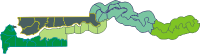
Districts of Gambia
Gambia is divided into a city and five divisions. Alternatively, it is divided into eight local government areas (LGAs), where each LGA is
either a division or a part of one. The LGAs, and hence the divisions, are further subdivided into districts. These maps show the
boundaries of the districts: Map  Map . There are some minor discrepancies among various lists of
districts. The following list is one way to break up the area of Gambia.
Map . There are some minor discrepancies among various lists of
districts. The following list is one way to break up the area of Gambia.
| District | HASC | LGA | Pop-2013 |
|---|---|---|---|
| Banjul | GM.BJ.BJ | L | 31,054 |
| Basse | GM.UR.BS | E | 49,102 |
| Central Baddibu | GM.NB.CB | N | 19,491 |
| Foni Bintang-Karenai | GM.WE.FO | A | 17,119 |
| Foni Bondali | GM.WE.FB | A | 7,578 |
| Foni Brefet | GM.WE.FF | A | 14,523 |
| Foni Jarrol | GM.WE.FJ | A | 6,883 |
| Foni Kansala | GM.WE.FK | A | 14,125 |
| Illiasa | GM.NB.IL | N | 48,620 |
| Janjanbureh | GM.MC.JJ | H | 3,789 |
| Jarra Central | GM.LR.JC | O | 8,342 |
| Jarra East | GM.LR.JE | O | 16,034 |
| Jarra West | GM.LR.JW | O | 26,214 |
| Jimara | GM.UR.JM | E | 43,461 |
| Jokadu | GM.NB.JO | N | 22,312 |
| Kanifing | GM.BJ.KF | G | 377,134 |
| Kantora | GM.UR.KT | E | 38,354 |
| Kiang Central | GM.LR.KI | O | 8,661 |
| Kiang East | GM.LR.KG | O | 6,801 |
| Kiang West | GM.LR.KW | O | 14,990 |
| Kombo Central | GM.WE.KC | A | 140,029 |
| Kombo East | GM.WE.KE | A | 42,330 |
| Kombo North/Saint Mary | GM.WE.KN | A | 339,377 |
| Kombo South | GM.WE.KS | A | 106,780 |
| Lower Baddibu | GM.NB.LB | N | 17,961 |
| Lower Fuladu West | GM.MC.LF | H | 39,804 |
| Lower Niumi | GM.NB.LN | N | 57,088 |
| Lower Saloum | GM.MC.LS | R | 15,446 |
| Niamina Dankunku | GM.MC.ND | H | 6,083 |
| Niamina East | GM.MC.NE | H | 24,340 |
| Niamina West | GM.MC.NW | H | 7,141 |
| Niani | GM.MC.NI | R | 28,343 |
| Nianija | GM.MC.NJ | R | 9,876 |
| Sabach Sanjal | GM.NB.SS | N | 23,728 |
| Sami | GM.MC.SM | R | 24,365 |
| Sandu | GM.UR.SN | E | 23,659 |
| Tumana | GM.UR.TM | E | 37,206 |
| Upper Fuladu West | GM.MC.UF | H | 44,047 |
| Upper Niumi | GM.NB.UN | N | 30,880 |
| Upper Saloum | GM.MC.US | R | 18,673 | >
| Wuli East | GM.UR.WE | E | 23,612 |
| Wuli West | GM.UR.WW | E | 21,826 |
| 37 districts | 1,857,181 | ||
| |||
Other names of subdivisions:
Foni Bintang-Karenai: Foni Bintang Karanai (variant)
Janjanbureh: Georgetown, MacCarthy Island (obsolete); Janjangburreh (variant)
Kanifing: K.M.C., K.U.D.C. (variant)
Kombo North/Saint Mary: Kombo, Kombo North, Kombo Saint Mary (variant); Kombo Sainte Marie (French)
Niumi: Nuimi (variant)
Change history:
In 1996 four districts were split into nine new districts. Fulladu West was split into Upper Fuladu West and Lower Fuladu West. Upper Baddibu was split into Illiasa and Sabach Sanjal. Fulladu East was split into Basse, Jimara, and Tumana. Wuli was split into Wuli East and Wuli West. Below are the districts before 1996 and the districts used in the 2003 census:
| District | HASC | LGA | Pop-2003 | Pop-1993 |
|---|---|---|---|---|
| Banjul | GM.BJ.BJ | L | 34,828 | 42,326 |
| Central Baddibu | GM.NB.CB | N | 14,998 | 15,060 |
| Foni Bintang-Karenai | GM.WE.FO | A | 15,994 | 11,397 |
| Foni Bondali | GM.WE.FB | A | 6,049 | 4,594 |
| Foni Brefet | GM.WE.FF | A | 11,411 | 8,529 |
| Foni Jarrol | GM.WE.FJ | A | 5,943 | 5,355 |
| Foni Kansala | GM.WE.FK | A | 12,247 | 7,748 |
| Fulladu East | GM.UR.FE | E | 98,454 | 84,327 |
| Fulladu West | GM.MC.FW | H | 71,669 | 57,995 |
| Janjanbureh | GM.MC.JJ | H | 3,466 | 2,813 |
| Jarra Central | GM.LR.JC | O | 6,494 | 6,084 |
| Jarra East | GM.LR.JE | O | 12,505 | 11,272 |
| Jarra West | GM.LR.JW | O | 24,416 | 20,673 |
| Jokadu | GM.NB.JO | N | 17,850 | 14,874 |
| Kanifing | GM.BJ.KF | G | 322,410 | 228,214 |
| Kantora | GM.UR.KT | E | 30,402 | 26,502 |
| Kiang Central | GM.LR.KI | O | 7,886 | 7,282 |
| Kiang East | GM.LR.KG | O | 6,534 | 6,356 |
| Kiang West | GM.LR.KW | O | 14,711 | 13,479 |
| Kombo Central | GM.WE.KC | A | 84,315 | 56,094 |
| Kombo East | GM.WE.KE | A | 28,146 | 21,028 |
| Kombo North/Saint Mary | GM.WE.KN | A | 166,351 | 80,478 |
| Kombo South | GM.WE.KS | A | 62,531 | 39,694 |
| Lower Baddibu | GM.NB.LB | N | 15,157 | 14,391 |
| Lower Niumi | GM.NB.LN | N | 44,491 | 35,147 |
| Lower Saloum | GM.MC.LS | R | 13,524 | 14,179 |
| Niamina Dankunku | GM.MC.ND | H | 6,000 | 6,089 |
| Niamina East | GM.MC.NE | H | 19,034 | 15,402 |
| Niamina West | GM.MC.NW | H | 6,630 | 5,948 |
| Niani | GM.MC.NI | R | 22,242 | 18,531 |
| Nianija | GM.MC.NJ | R | 8,205 | 6,439 |
| Sami | GM.MC.SM | R | 19,157 | 16,073 |
| Sandu | GM.UR.SN | E | 18,321 | 14,689 |
| Upper Baddibu | GM.NB.UB | N | 55,370 | 55,438 |
| Upper Niumi | GM.NB.UN | N | 24,940 | 21,552 |
| Upper Saloum | GM.MC.US | R | 15,970 | 12,552 |
| Wuli | GM.UR.WU | E | 35,856 | 29,541 |
| 37 districts | 1,364,507 | 1,038,145 | ||
| ||||
I've added the populations from the 1993 and 2003 censuses. I also dropped Dappo district, because I can't find much evidence that it exists. It may have been absorbed into another district. Banjul may be divided into the districts of Banjul Central, Banjul North, and Banjul South, but most sources show it as just one district.
| Back to main statoids page | Last updated: 2017-06-30 |
| Copyright © 2001, 2003, 2004 by Gwillim Law. | |
| Copyright © 2017 by Shirley Law. | |